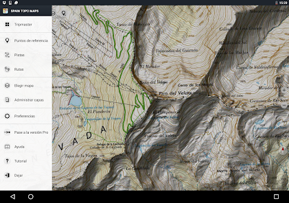
Spain Topo Maps
Contains adsIn-app purchases
4.8star
5.75K reviewsinfo
100K+
Downloads

PEGI 3
info


About this app
+++ New GPS Mapping App +++
Easy to use Outdoor/Offline GPS navigation app with access to the best topographic maps and aerial images for Spain.
Including Balearic Islands and Canary Islands
++ For offline use PRO features needed ! ++
Turn your Andoid Phone/Tablet into an outdoor GPS for trips into the backcountry WITHOUT CELL COVERAGE. This app gives you similar mapping options as you might know from GPS handhelds.
Included FREE map layers:
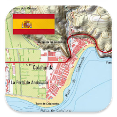
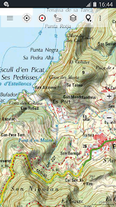
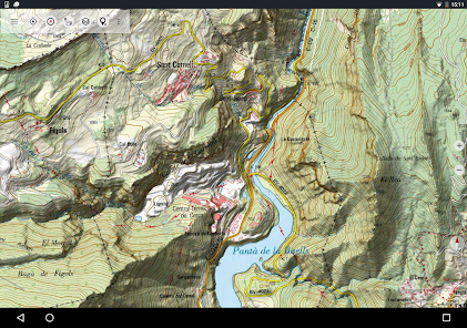
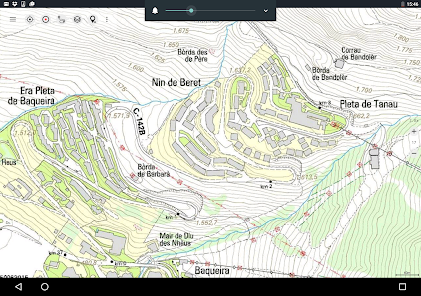
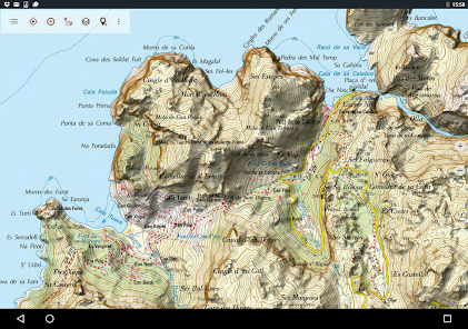
• Spain Topo Map: Mapa Topográfico Nacional 1:50.000 & 1:25.000 (IGN MTN25 & MTN50)
• IGN Base Map: Base Topográfica Nacional 1:25.000 (BTN25 & BCN25)
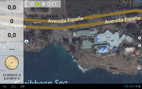
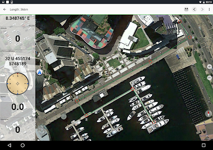
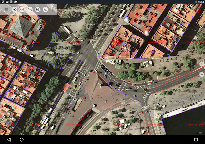
• Spain Imagery: High resolution aerial imagery. Plan Nacional de Ortofotografía Aérea (PNOA)
• Catalonia Topo Maps: High resolution topographic maps for Catalonia
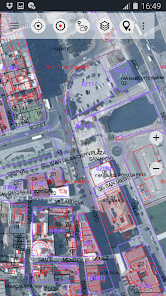
• Land Register Map: Cartografía Catastral
• OpenStreetMaps : These crowdsourced maps are a very useful addition to other map layers. Contains many unique features.
• OpenCycleMaps: These maps are ideal to plan bicycle trips
• ESRI Topographic
• ESRI Aerial Images
• ESRI Street Map
• Google Road Map (online access only)
• Google Satellite Images (online access only)
• Google Terrain Map (online access only)
• Bing Road Map (online access only)
• Bing Satellite Images (online access only)
• Earth At Night
• Hillshading overlay
Main features for outdoor-navigation:
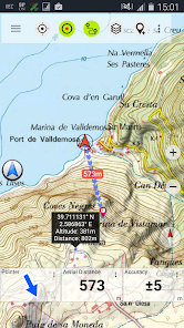
• Create and edit Waypoints
• GoTo-Waypoint-Navigation
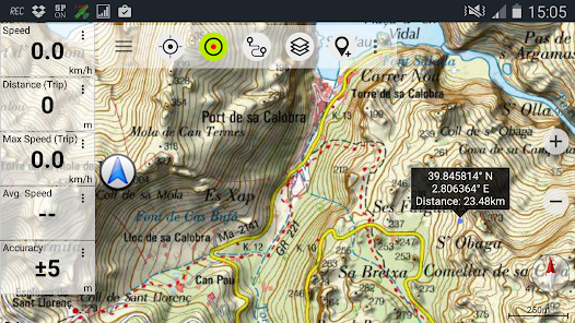
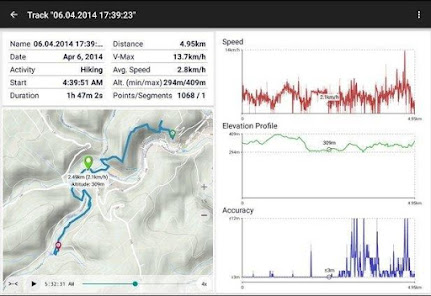
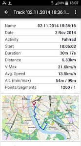
• Track Recording (with speed, elevation and accuracy profile)
• Tripmaster with fields for odometer, average speed, bearing, elevation, etc.
• GPX/KML/KMZ Export
• Search (placenames, POIs, streets)
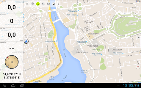
• Customizable datafields in Map View and Tripmaster (e.g. Speed, Distance, Compass, ...)
• Share Waypoints, Tracks or Routes (via eMail, Whatsapp, Dropbox, Facebook, ..)
• Display coordinates in Lat/Lon, UTM or MGRS/USNG (Military Grid/ US National Grid)
• Record & share tracks with statistics & elevation profile
• Rotate map (Track Up & North Up)
• Get Elevation by long click on map
• Track Replay
• and many more ...
Available Pro features: (Pro features available via In App Purchase)
• Offline Use - no cell coverage needed
• Easy+Fast Bulk-download of map tiles for OFFLINE USAGE (not for Google and Bing maps)
• Create and edit Routes
• Route-Navigation (Point-to-Point Navigation)
• GPX/KML/KMZ Import
• unlimited Waypoints & Tracks
• Add other Map Tile-Server
• No Ads
Offline Use:
All viewed map tiles are kept in cache. To cache large areas you need to purchase Pro features.
Use this navigation app for outdoor activities like hiking, biking, camping, climbing, riding, skiing, canoeing, hunting, offroad 4WD tours or search&rescue (SAR).
Add custom waypoints in longitude/latitude, UTM or MGRS/USNG format with WGS84 datum.
Import/Export/Share GPS-Waypoints/Tracks/Routes in GPX or Google Earth KML/KMZ format.
Preload FREE map data for areas without cell service (Pro feature !).
Comments and feature requests to [email protected]
Have a look at our other outdoor navigation apps: /store/search?q=atlogis
+++ We DO NOT track any user activities or collect any user data ! +++
Easy to use Outdoor/Offline GPS navigation app with access to the best topographic maps and aerial images for Spain.
Including Balearic Islands and Canary Islands
++ For offline use PRO features needed ! ++
Turn your Andoid Phone/Tablet into an outdoor GPS for trips into the backcountry WITHOUT CELL COVERAGE. This app gives you similar mapping options as you might know from GPS handhelds.
Included FREE map layers:
• Spain Topo Map: Mapa Topográfico Nacional 1:50.000 & 1:25.000 (IGN MTN25 & MTN50)
• IGN Base Map: Base Topográfica Nacional 1:25.000 (BTN25 & BCN25)
• Spain Imagery: High resolution aerial imagery. Plan Nacional de Ortofotografía Aérea (PNOA)
• Catalonia Topo Maps: High resolution topographic maps for Catalonia
• Land Register Map: Cartografía Catastral
• OpenStreetMaps : These crowdsourced maps are a very useful addition to other map layers. Contains many unique features.
• OpenCycleMaps: These maps are ideal to plan bicycle trips
• ESRI Topographic
• ESRI Aerial Images
• ESRI Street Map
• Google Road Map (online access only)
• Google Satellite Images (online access only)
• Google Terrain Map (online access only)
• Bing Road Map (online access only)
• Bing Satellite Images (online access only)
• Earth At Night
• Hillshading overlay
Main features for outdoor-navigation:
• Create and edit Waypoints
• GoTo-Waypoint-Navigation
• Track Recording (with speed, elevation and accuracy profile)
• Tripmaster with fields for odometer, average speed, bearing, elevation, etc.
• GPX/KML/KMZ Export
• Search (placenames, POIs, streets)
• Customizable datafields in Map View and Tripmaster (e.g. Speed, Distance, Compass, ...)
• Share Waypoints, Tracks or Routes (via eMail, Whatsapp, Dropbox, Facebook, ..)
• Display coordinates in Lat/Lon, UTM or MGRS/USNG (Military Grid/ US National Grid)
• Record & share tracks with statistics & elevation profile
• Rotate map (Track Up & North Up)
• Get Elevation by long click on map
• Track Replay
• and many more ...
Available Pro features: (Pro features available via In App Purchase)
• Offline Use - no cell coverage needed
• Easy+Fast Bulk-download of map tiles for OFFLINE USAGE (not for Google and Bing maps)
• Create and edit Routes
• Route-Navigation (Point-to-Point Navigation)
• GPX/KML/KMZ Import
• unlimited Waypoints & Tracks
• Add other Map Tile-Server
• No Ads
Offline Use:
All viewed map tiles are kept in cache. To cache large areas you need to purchase Pro features.
Use this navigation app for outdoor activities like hiking, biking, camping, climbing, riding, skiing, canoeing, hunting, offroad 4WD tours or search&rescue (SAR).
Add custom waypoints in longitude/latitude, UTM or MGRS/USNG format with WGS84 datum.
Import/Export/Share GPS-Waypoints/Tracks/Routes in GPX or Google Earth KML/KMZ format.
Preload FREE map data for areas without cell service (Pro feature !).
Comments and feature requests to [email protected]
Have a look at our other outdoor navigation apps: /store/search?q=atlogis
+++ We DO NOT track any user activities or collect any user data ! +++
Updated on
Safety starts with understanding how developers collect and share your data. Data privacy and security practices may vary based on your use, region and age. The developer provided this information and may update it over time.

This app may share these data types with third parties
Personal info, App activity and 2 others

No data collected
Learn more about how developers declare collection

Data is encrypted in transit

You can request that data be deleted
Ratings and reviews
4.9
5.17K reviews

Terence Faulkner
- Flag inappropriate
26 January 2025
I don't often bother to rate Apps, but this is so good I've made the effort. Got it for cycling and walking in Spain. Which it's perfect for. When I got home found it works in the UK to. Easy to map and follow routes on the different layers. Great value

Steven Lefavour
- Flag inappropriate
12 December 2021
This is a great tool. The free version gives you access to pretty detailed aerial view, not satellite so the resolution is pretty sharp. Topo maps are very detail rich; the terrain features don't always line up with what is shown on Google or Here maps. I wish there was access to the legends and margin data for these maps; don't know what all of these symbols represent. I'll probably spring for the paid version so I'll be able to draw and save routes and waypoints, and to use all their products.
14 people found this review helpful

Las Dunas Javea Holiday Apartment
- Flag inappropriate
13 June 2022
This app enhances my life. Seriously! I have been using it for a few years now and barely ever let down. I can import routes, save my routes. Measure and plan, with the different layers see other features, it means I have confidence when out walking and cycling. I find most layers work in Portugal and France too, not tried other countries except for the UK!! Yes UK! Forget Brexit, I am here now and it is helping me find my about here too, little English footpaths and cycle tracks. I love it!
10 people found this review helpful
What's new
・Pro versions: Auto-routing with profiles "Pedestrian", "Hiking", "Bike" & "MTB"
・Saving maps along a track / route
・Bug fixes
・Saving maps along a track / route
・Bug fixes
App support
About the developer
Atlogis Geoinformatics GmbH & Co. KG
Unter den Ulmen 8
33330 Gütersloh
Germany
+49 171 1738949


