
CarryMap
100K+
Téléchargements

PEGI 3
info


À propos de l'application
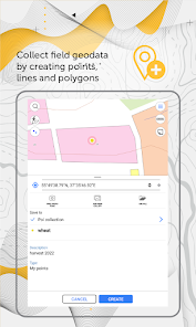
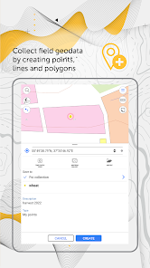
Collect field data, add and edit point, line, and polygon features on your mobile map, share your data with peers.
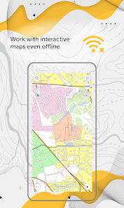
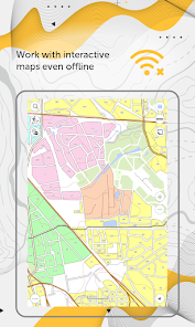
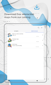
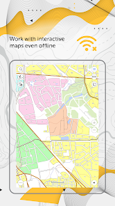
Access your maps everywhere you go, all app features are available even offline. CarryMap provides seamless field work without authorization, payments and in-app purchases. With the app you can use maps prepared in ArcGIS or download free maps covering various territories from our catalog. The maps provided in the catalog were created based on OpenStreetMap data.
1. Work in the app without authorization, payments and in-app purchases.
2. Add your own maps or download free maps from our catalog.
3. Create and edit point, line, and polygon features on map.
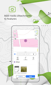
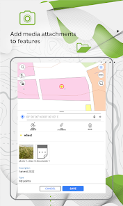
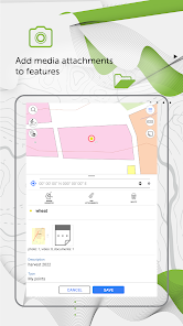
4. Add media attachments (photo, video and documents) to features.
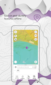
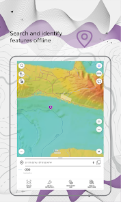
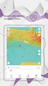
5. Search and identify features offline.
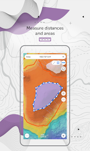
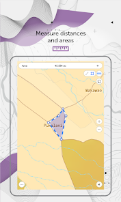
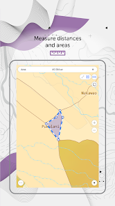
6. Measure distances and areas.
7. Create points on-the-fly using your device camera.
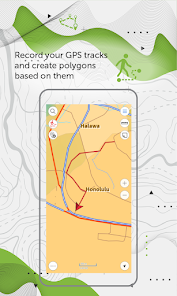
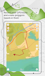
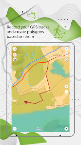
8. Record your GPS tracks and create polygons based on them
9. Add graphic marks in the form of text, arrows or free hand graphic to the mobile map.
10. Use external Bad Elf GPS receiver to find your current location.
11. Save selected map areas as bookmarks for quicker access.
12. Use map features as landmarks or destination points.
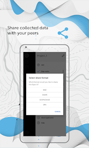
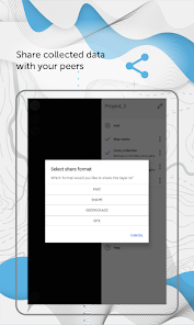
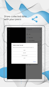
13. Share collected data in GPKG, GPX, KML/KMZ and SHP formats.
Specialists from electrical energy industry, agriculture, geology and geodesy, housing and utility, water and land resources management, ecology and incident management, urban management, and other areas worldwide successfully use CarryMap app for working with maps and solving their everyday job tasks.
CarryMap app is provided for work with maps of specific mobile format CMF2. To export your ArcGIS maps to this format, you will need CarryMap Builder – an extension to ArcGIS Desktop. Visit https://builder.carrymap.com/ to learn more about CarryMap Builder.
To learn more about CarryMap application, visit https://carrymap.com.
Your questions or comments are welcome at [email protected].
Subscribe to our Facebook page at https://www.facebook.com/carrymap/.
Subscribe to our YouTube channel at https://www.youtube.com/c/CarryMap/videos.
Access your maps everywhere you go, all app features are available even offline. CarryMap provides seamless field work without authorization, payments and in-app purchases. With the app you can use maps prepared in ArcGIS or download free maps covering various territories from our catalog. The maps provided in the catalog were created based on OpenStreetMap data.
1. Work in the app without authorization, payments and in-app purchases.
2. Add your own maps or download free maps from our catalog.
3. Create and edit point, line, and polygon features on map.
4. Add media attachments (photo, video and documents) to features.
5. Search and identify features offline.
6. Measure distances and areas.
7. Create points on-the-fly using your device camera.
8. Record your GPS tracks and create polygons based on them
9. Add graphic marks in the form of text, arrows or free hand graphic to the mobile map.
10. Use external Bad Elf GPS receiver to find your current location.
11. Save selected map areas as bookmarks for quicker access.
12. Use map features as landmarks or destination points.
13. Share collected data in GPKG, GPX, KML/KMZ and SHP formats.
Specialists from electrical energy industry, agriculture, geology and geodesy, housing and utility, water and land resources management, ecology and incident management, urban management, and other areas worldwide successfully use CarryMap app for working with maps and solving their everyday job tasks.
CarryMap app is provided for work with maps of specific mobile format CMF2. To export your ArcGIS maps to this format, you will need CarryMap Builder – an extension to ArcGIS Desktop. Visit https://builder.carrymap.com/ to learn more about CarryMap Builder.
To learn more about CarryMap application, visit https://carrymap.com.
Your questions or comments are welcome at [email protected].
Subscribe to our Facebook page at https://www.facebook.com/carrymap/.
Subscribe to our YouTube channel at https://www.youtube.com/c/CarryMap/videos.
Date de mise à jour
La sécurité, c'est d'abord comprendre comment les développeurs collectent et partagent vos données. Les pratiques concernant leur confidentialité et leur protection peuvent varier selon votre utilisation, votre région et votre âge. Le développeur a fourni ces informations et peut les modifier ultérieurement.

Aucune donnée partagée avec des tiers
En savoir plus sur la manière dont les développeurs déclarent le partage

Aucune donnée collectée
En savoir plus sur la manière dont les développeurs déclarent la collecte
Nouveautés
• New option to work with raster maps in MBTiles format.
• New ability to record and save voice comments (audio attachments) when creating and describing features on the map.
• New option to set and view Z coordinates of point features.
• New option to view information about traveled distance when moving to the destination point.
• Automatic creation of a point based on the user's location.
Assistance de l'appli
À propos du développeur
XTools Pro , Inc
333 W Maude Ave Ste 207
Sunnyvale, CA 94085
United States
+1 669-290-9014


