
Locus Map 3 Classic
ଆପ୍ ମଧ୍ୟରେ କ୍ରୟଗୁଡ଼ିକ
4.7star
46.7ହଟି ସମୀକ୍ଷାinfo
100ହ+
ଡାଉନଲୋଡଗୁଡ଼ିକ

PEGI 3
info


ଏହି ଆପ୍ ବିଷୟରେ
The third generation of a navigation application for outdoor enthusiasts - hikers, mountain bikers, mountaineers, trail runners, or geocachers (formerly Locus Map Pro). Fully developed until 2022, now in maintenance mode - the main development is focused on the fourth generation - Locus Map 4.
Locus Map 3 Classic offers true multi-functionality and flexibility:
• advanced navigation capability, supporting external online and offline routing services
• wide choice of offline and online maps
• advanced map tools - map overlays, offsets, WMS sources support
• tools for monitoring sports activities - tracking, audio coach, charts, statistics, support of external sensors (GPS, HRM, cadence...)
• worldwide weather forecast 24/7
• sophisticated tools for geocaching • graphic and calculation tools, online/offline logging, support of trackables, Pocket Queries, spoilers…
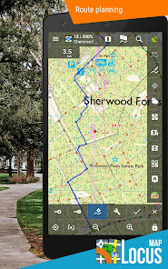
Map portfolio
Offline maps
• LoMaps - OSM-based vector maps of the whole world. Containing themes for hiking, biking, winter sports, road or city use - three LoMaps are for free
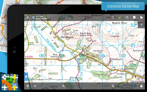
• Maps of renowned cartographic publishers:
• Germany, Austria, Italy - Outdooractive Summer and Winter
• United States - Accuterra trail maps
• Switzerland - SwissTopo
• United Kingdom - Ordnance Survey (eq. to Landranger and Explorer)
• France - IGN topo and satellite
• Spain - CNIG
• Poland - Compass hiking maps
• Czechia, Slovakia - SHOCart
• other countries - PZS Slovenia, IGN Belgium, Cartographia Hungary, etc.
• support of external maps in SQLite, TAR, MBT, GEMF, Orux, or RMAP formats
Online maps
• World - various OSM-based maps
• US - USGS
• Europe - Outdooractive Summer and Winter, IGN France and Belgium, Kapsi.fi, Turistautak, Cartographia, Skoterleder, Statkart, UMP and Osmapa.pl (Poland) and many others
• Asia etc. - GSI (Japan), Visicom (former Soviet countries), Navigasi (Indonesia), NzTopoMaps (New Zealand)...
Most of the online maps can be downloaded for offline use.
WMS maps
• meteorological maps, NASA maps, cadastral maps...
Features:
Navigation and guidance
• turn-by-turn voice navigation with support of online/offline routing services
• beeline guidance to a point (on the map or by compass) or along a route with notifications
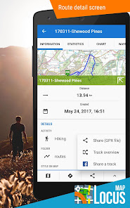
Tracks&Routes
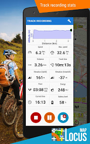
• multi-profile track recording
• charts&statistics
• audio coach for efficient workouts
• support of Bluetooth/ANT+ external sensors - HRM, speed/cadence, GPS, NMEA
• route planning and editing tools
• import/export of routes/tracks from/to various formats (KML, KMZ, GPX...) and web services (Strava, Runkeeper, Google Earth, etc...)
• customizable bike computer dashboard
Points
• creating own database - filtering, search, sorting
• import/export in many formats, web services support
• LoPoints - database of OSM POIs
Map tools
• map overlay, calibration, and offsets
• support of various external map formats and coordinate systems
• support of geotagged photos, OSM notes
Search
• addresses online and offline
• LoPoints, GeoNames, GNS, and Wikipedia
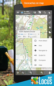
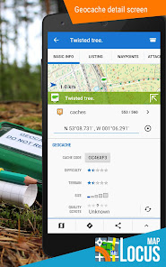
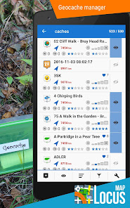
Geocaching
• downloading geocaches via Geocaching4Locus add-on
• offline and online logging
• support of waypoints, PocketQuery, trackables, spoilers
• graphic and calculation tools
Live tracking
• private or public sharing/monitoring of location in real-time
Other features and tools
• parking assistant, worldwide weather forecast, QR code generator...
Locus Map 3 Classic is highly customizable. Everything can be set according to the user's needs - the main menu, function panels, dashboards, custom screens... The functionality of the app can be further extended by numerous add-ons - Locus Map Watch, Augmented reality, etc.
This application uses device administrator permission.
Locus Map 3 Classic offers true multi-functionality and flexibility:
• advanced navigation capability, supporting external online and offline routing services
• wide choice of offline and online maps
• advanced map tools - map overlays, offsets, WMS sources support
• tools for monitoring sports activities - tracking, audio coach, charts, statistics, support of external sensors (GPS, HRM, cadence...)
• worldwide weather forecast 24/7
• sophisticated tools for geocaching • graphic and calculation tools, online/offline logging, support of trackables, Pocket Queries, spoilers…
Map portfolio
Offline maps
• LoMaps - OSM-based vector maps of the whole world. Containing themes for hiking, biking, winter sports, road or city use - three LoMaps are for free
• Maps of renowned cartographic publishers:
• Germany, Austria, Italy - Outdooractive Summer and Winter
• United States - Accuterra trail maps
• Switzerland - SwissTopo
• United Kingdom - Ordnance Survey (eq. to Landranger and Explorer)
• France - IGN topo and satellite
• Spain - CNIG
• Poland - Compass hiking maps
• Czechia, Slovakia - SHOCart
• other countries - PZS Slovenia, IGN Belgium, Cartographia Hungary, etc.
• support of external maps in SQLite, TAR, MBT, GEMF, Orux, or RMAP formats
Online maps
• World - various OSM-based maps
• US - USGS
• Europe - Outdooractive Summer and Winter, IGN France and Belgium, Kapsi.fi, Turistautak, Cartographia, Skoterleder, Statkart, UMP and Osmapa.pl (Poland) and many others
• Asia etc. - GSI (Japan), Visicom (former Soviet countries), Navigasi (Indonesia), NzTopoMaps (New Zealand)...
Most of the online maps can be downloaded for offline use.
WMS maps
• meteorological maps, NASA maps, cadastral maps...
Features:
Navigation and guidance
• turn-by-turn voice navigation with support of online/offline routing services
• beeline guidance to a point (on the map or by compass) or along a route with notifications
Tracks&Routes
• multi-profile track recording
• charts&statistics
• audio coach for efficient workouts
• support of Bluetooth/ANT+ external sensors - HRM, speed/cadence, GPS, NMEA
• route planning and editing tools
• import/export of routes/tracks from/to various formats (KML, KMZ, GPX...) and web services (Strava, Runkeeper, Google Earth, etc...)
• customizable bike computer dashboard
Points
• creating own database - filtering, search, sorting
• import/export in many formats, web services support
• LoPoints - database of OSM POIs
Map tools
• map overlay, calibration, and offsets
• support of various external map formats and coordinate systems
• support of geotagged photos, OSM notes
Search
• addresses online and offline
• LoPoints, GeoNames, GNS, and Wikipedia
Geocaching
• downloading geocaches via Geocaching4Locus add-on
• offline and online logging
• support of waypoints, PocketQuery, trackables, spoilers
• graphic and calculation tools
Live tracking
• private or public sharing/monitoring of location in real-time
Other features and tools
• parking assistant, worldwide weather forecast, QR code generator...
Locus Map 3 Classic is highly customizable. Everything can be set according to the user's needs - the main menu, function panels, dashboards, custom screens... The functionality of the app can be further extended by numerous add-ons - Locus Map Watch, Augmented reality, etc.
This application uses device administrator permission.
ଗତ ଅପଡେଟର ସମୟ
ଡେଭେଲପରମାନେ ଆପଣଙ୍କ ଡାଟାକୁ କିପରି ସଂଗ୍ରହ ଏବଂ ସେୟାର କରନ୍ତି ସେହି ଧାରଣା ସହିତ ସୁରକ୍ଷା ଆରମ୍ଭ ହୁଏ। ଆପଣଙ୍କ ବ୍ୟବହାର, ଅଞ୍ଚଳ ଏବଂ ବୟସ ଆଧାରରେ, ଡାଟା ଗୋପନୀୟତା ଓ ସୁରକ୍ଷା କାର୍ଯ୍ୟପଦ୍ଧତିଗୁଡ଼ିକ ଭିନ୍ନ ହୋଇପାରେ। ଡେଭେଲପର ଏହି ସୂଚନା ପ୍ରଦାନ କରିଛନ୍ତି ଏବଂ ସେ ସମୟାନୁସାରେ ଏହାକୁ ଅପଡେଟ କରିପାରନ୍ତି।


ମୂଲ୍ୟାଙ୍କନ ଓ ସମୀକ୍ଷା
4.7
43.8ହଟି ସମୀକ୍ଷା
ନୂଆ କଣ ଅଛି
Various adjustments and fixes as part of routine maintenance.
ଆପ ସପୋର୍ଟ
ଡେଭେଲପରଙ୍କ ବିଷୟରେ


