
bergfex: hiking & tracking
Contains adsIn-app purchases
4.7star
10.4K reviewsinfo
1M+
Downloads

PEGI 3
info


About this app
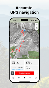
The bergfex: hiking & tracking app is a must-have for every hike, ski tour or other outdoor activity.
Find the most beautiful hiking trails in your area or create personal tours with our route planner and track all your outdoor activities. Precise GPS navigation, detailed hiking maps for the entire Alpine region and other useful features bring you safely to your destination.
Get to know the bergfex hiking app for free!
Find hikes or ski tours that suit you
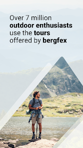
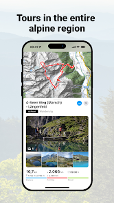
The bergfex tours app contains around 200,000 hiking trails, ski tours, running routes and mountain bike trails throughout Europe. Detailed tour descriptions, topographic hiking maps for the entire Alpine region and filter options make it easy to find the ideal tour.
Tour planner and hiking navigation
You haven't found the perfect hiking or ski tour yet? Then use the bergfex tour planner. In just a few steps you can create your personal hike and let it navigate you to the summit. The precise GPS hiking navigator won't let you down even in the mountains.
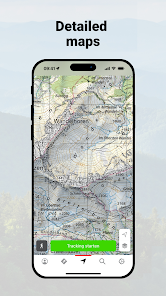
Detailed maps
Our maps for the entire European Alpine region come from OpenStreetMap (OSM). This means that when planning your route and while hiking, you can be sure that you will find the right route thanks to regularly updated maps.
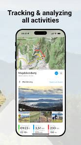
Tracking hiking routes and trails
Track the distance covered while hiking, ski touring, running or mountain biking and get comprehensive statistics such as duration, altitude metres, elevation profile, distance and speed. A heat map shows you all the activities you have recorded so far.
Route and fitness tracking combined
Keep track of your fitness level and activities! Optionally, you can wear a Bluetooth heart rate monitor while hiking, ski touring or other sports to get even more detailed information about your fitness level.
Garmin Connect, websync and GPX-import
Your hikes and planned tours are automatically synchronised with your bergfex account. Tracked activities are also displayed in Garmin Connect and Polar Flow. Self-created routes can be exported and imported via GPX file.
_____________________
Test many pro functions for 7 days free of charge & without any commitment
Register in the hiking app and test the helpful functions of our PRO subscription on your next hike:
• name surrounding peaks with our "Peak Names" feature
• access to over 9,500 webcams to get live insights into the region
• 3D maps show the terrain, the surroundings and the route in detail
• more detailed map material thanks to higher zoom level
• warning signal when leaving the route
• overlay to visualise slope steepness >30°, 35°, 40°, 45°
• official hiking maps such as ÖK50, SwissMap, etc.
• offline map material for navigation even without an active internet connection
• satellite map with additional information and points of interest
• intermediate destinations for route planning
• zones for heart rate measurement
• hiking, ski mountaineering and more without advertising
_____________________
Any questions?
If you have any questions or comments about our app, please send us an email at: [email protected]
Note: Continuous GPS usage can result in a severe reduction in battery life.
Terms of use: bergfex.com/c/agb
Privacy: bergfex.com/c/datenschutz/
Find the most beautiful hiking trails in your area or create personal tours with our route planner and track all your outdoor activities. Precise GPS navigation, detailed hiking maps for the entire Alpine region and other useful features bring you safely to your destination.
Get to know the bergfex hiking app for free!
Find hikes or ski tours that suit you
The bergfex tours app contains around 200,000 hiking trails, ski tours, running routes and mountain bike trails throughout Europe. Detailed tour descriptions, topographic hiking maps for the entire Alpine region and filter options make it easy to find the ideal tour.
Tour planner and hiking navigation
You haven't found the perfect hiking or ski tour yet? Then use the bergfex tour planner. In just a few steps you can create your personal hike and let it navigate you to the summit. The precise GPS hiking navigator won't let you down even in the mountains.
Detailed maps
Our maps for the entire European Alpine region come from OpenStreetMap (OSM). This means that when planning your route and while hiking, you can be sure that you will find the right route thanks to regularly updated maps.
Tracking hiking routes and trails
Track the distance covered while hiking, ski touring, running or mountain biking and get comprehensive statistics such as duration, altitude metres, elevation profile, distance and speed. A heat map shows you all the activities you have recorded so far.
Route and fitness tracking combined
Keep track of your fitness level and activities! Optionally, you can wear a Bluetooth heart rate monitor while hiking, ski touring or other sports to get even more detailed information about your fitness level.
Garmin Connect, websync and GPX-import
Your hikes and planned tours are automatically synchronised with your bergfex account. Tracked activities are also displayed in Garmin Connect and Polar Flow. Self-created routes can be exported and imported via GPX file.
_____________________
Test many pro functions for 7 days free of charge & without any commitment
Register in the hiking app and test the helpful functions of our PRO subscription on your next hike:
• name surrounding peaks with our "Peak Names" feature
• access to over 9,500 webcams to get live insights into the region
• 3D maps show the terrain, the surroundings and the route in detail
• more detailed map material thanks to higher zoom level
• warning signal when leaving the route
• overlay to visualise slope steepness >30°, 35°, 40°, 45°
• official hiking maps such as ÖK50, SwissMap, etc.
• offline map material for navigation even without an active internet connection
• satellite map with additional information and points of interest
• intermediate destinations for route planning
• zones for heart rate measurement
• hiking, ski mountaineering and more without advertising
_____________________
Any questions?
If you have any questions or comments about our app, please send us an email at: [email protected]
Note: Continuous GPS usage can result in a severe reduction in battery life.
Terms of use: bergfex.com/c/agb
Privacy: bergfex.com/c/datenschutz/
Updated on
Safety starts with understanding how developers collect and share your data. Data privacy and security practices may vary based on your use, region, and age. The developer provided this information and may update it over time.


Ratings and reviews
4.7
9.93K reviews

A Google user
- Flag inappropriate
April 15, 2020
Nice app! I used the free version for two years and then bought the pro version. Good value for money. When I had a problem (the app didn't record the track anymore), I sent a mail to Bergfex and I was promptly helped. Turned out, that de default settings in the newly installed Android version had caused my problem. Great help, much appreciated :-) !!
15 people found this review helpful

Mudhead
- Flag inappropriate
- Show review history
August 24, 2024
actually great app but... yesterday I was on the TET in Bosnia on motorbike. My phone died and after restarting I just got a black screen when I tried to open the "offline" map. For some reason the app needs an internet connect., probably to confirm I bought it, Whoever has any idea about this country, the TET and the wildlife can imagine how damn lost I was... I managed to get back to civilization after 3 hours of driving through the forest after sun set. I will talk to an lawyer about that...
3 people found this review helpful
bergfex GmbH
September 2, 2024
Hallo Tobias, danke für Dein Feedback - es tut uns leid, dass Du diese Erfahrung hast machen müssen. Bitte melde Dich mit einer kurzen Nachricht unter [email protected], gerne schauen wir uns Dein Problem genauer an. Viele Grüße, Team bergfex

Andrej Zupančič
- Flag inappropriate
- Show review history
January 7, 2023
A very good app, with possibility the best maps I've encountered so far (clean, crisp, graphically pleasing, with near 3D feel). Altitude data most accurate of all navigation apps I've tried. Works great with Garmin, not sure about other brands. The only thing that bothers me is the occasional mix of German and English language, but let's hope the developers will eventually work out this glitch.
28 people found this review helpful
bergfex GmbH
January 17, 2023
Hallo Andrej, danke für das äußerst positive Feedback - es freut uns sehr, dass Dir die App so gut gefällt! Bezüglich der unterschiedlichen Sprachen: Kannst Du Dich hierzu vielleicht unter [email protected] melden und uns mitteilen, wo genau dieses Problem auftritt? Gerne würden wir uns das näher ansehen. Danke und viele Grüße, Team bergfex
What’s new
Having questions or problems with our app? Contact us via email: [email protected]
- Improved UX
- Stability and usability improvements
- Improved UX
- Stability and usability improvements
App support
About the developer


